
I took a little side trip with a friend to visit the geographical center of the nation. Turns out that it’s a bit hard to find. Apparently it’s hidden down some gravel road, behind a barbed wire fence, in the middle of a pasture somewhere outside of Belle Fourche, SD.
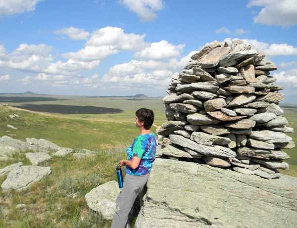
While we were searching, we found a monument behind a fence far up an old, worn piece of black top that was gated off from the main road. We parked at the gate and hiked up the road then found a path that led up the side of the hill. At the top of the hill was a fenced area surrounding some old shepherd’s monuments. The story goes that the shepherds would pass the time by building rock cairns on the top of the hills where they would sit while watching their sheep.

Topper and me at the shepherd’s monument
I read somewhere on the internet that the marker for the geographical center of the 50 states is quite near where we were, but we didn’t see it. All we saw were the stone markers and an old wooden sign telling about the shepherd’s stone monuments. On the top of the same hill we could see other stones sunk into the ground in circular patterns. They were apparently the remains of old tepee stones–the foundations of old native American encampments. There were also flakes of stone in the ant hills in the same area, remnants of a time when stone tools were formed there.
The view from the top of the mountain was incredible. We could see for miles and miles in every direction. Far in the distance we could see Castle Rock Butte and several other formations. It was a perfect afternoon, warm, sunny and utterly peaceful. I read somewhere that the stone formations in the area were full of rattlesnake nests, but I never saw a single snake. Just several areas where deer had obviously lain to rest.
Castle Rock Butte in the distance

A view from the top
After spending some time sitting in the sun, exploring and taking pictures at the top, we headed back down the overgrown path to the old road and hiked back to our car. Which was a lot easier to say than do, as a hike of over a mile in each direction hadn’t been anticipated by either of us. At least my friend was wearing boots, all I had on were sandals that barely clung to my feet, causing me to have to side-step all the way down the path everywhere it was the least bit steep, so that I didn’t fall. We won’t mention the small cacti that seemed to be everywhere on top of the hill that made every step a new adventure.

Sunflowers

Tepee Stones
But hey, we got up, we got down. A lovely day was had by all (especially Topper, my little dog, who was in “what is this strange new smell?” heaven), I got some nice pictures and we were at least in the right area for the geo. center of the U.S., even if we never saw it.
