
As much fun as visiting family near Denver was, I eventually had to move on. I needed to cross the Rockies and continue my westward journey. This was not done without some measure of trepidation. I had no idea how my new RV would handle on the steep rises and downgrades of the passage above Denver.
Denver itself is “only” about 5500 above sea level. High enough that the altitude and shortage of oxygen takes some getting used to. But no big deal in comparison to how high the Rocky Mountains actually are. Topper and I would be crossing at over 11,000 feet, quite a jump from where I had been for the past few days.
I needn’t have been concerned.
It turned out that the worst part of the trip was all the construction and the traffic back-ups created by it. The first section of stop-and-go lasted about 45 minutes and ended before I got really sick of it. The scenery was so nice that the slow-down simply allowed me more time to take it all in.
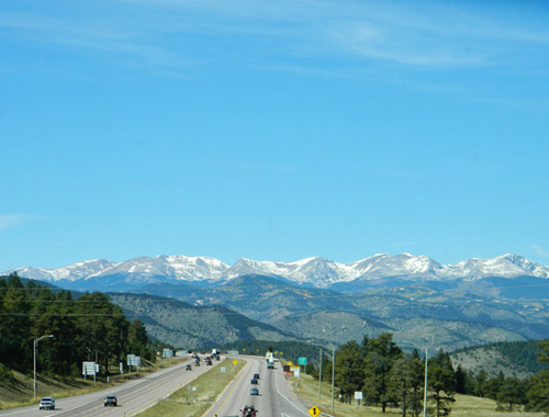
Approaching the Rockies
About the time the traffic started to flow again, the really steep climb started. Yes, I had to go a little slower, but not nearly as slow as many of the loaded semis. I only fell below 40 mph one time when I was blocked in behind a truck carrying a load so large that it was barely doing 20.
And through it all, the temperature gauge on my RV never wavered. It stayed exactly where it had been on the flattest roads. I was really pleased. There were a lot of cars sitting on the side of the road with their hoods open whose owners would have loved to say the same. I hit the Eisenhower Tunnel and sailed on through. The Eisenhower was the first of the two tunnels built through the peaks to facilitate the traffic flow across the Continental Divide. It carries the west-bound traffic. The Johnson tunnel was built alongside a few years later and carries the east-bound traffic. Both tunnels are quite long, but well-lit and are quite comfortable to drive.

Eisenhower Tunnel
Almost as soon as I exited on the other side of the divide, the really beautiful scenery started. Since it had snowed just a couple of days before, there was still plenty of snow on the higher peaks. Just enough to give everything that “picture postcard” look. Which meant that I felt obligated to stop at almost every scenic overlook to take a few pictures.

after exiting the tunnel
It had been at least 18 years since I had driven across this section of the Rockies, so all the pictures I have of the area predate the digital age. And many have suffered the fading colors that so many photos of the film-era have fallen victim to. So it was nice to have the chance to update my mementos of the area.


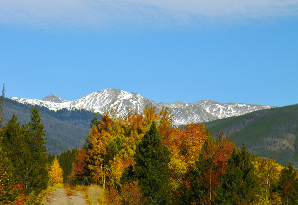
- A little fall color

Scenic overlook
There are several areas with long, steep down-grades on the other side of the divide–along with a few more steep climbs. The down-grades are posted with signs that limit vehicles over 26,000 pounds to speeds of 45 mph and under. They also let you know just how many miles that grade will last. The longest, steepest grades have special ramps built off the side of the road to allow trucks that lose their brakes on the way down to have a place to come to a stop. If you’ve never driven a really steep mountain road you don’t realize just how necessary they can be.

Truck escape ramp
I was very happy with the way the new RV handled. It took the “downs” as well as it had taken the “ups”. It has a grade brake that allows the engine to take a lot of the load off the regular brakes–very similar to the type of braking system that a semi uses. Not as hefty, but it certainly got the job done. A flip of the switch and I never had to worry about my brakes over-heating. Since the manual that came with the RV lists its weight at around 22,000 pounds (without gas, water or personal items on board), it’s not something you want to have get away from you….
After the worst of the ups-and-downs was over, I stopped to take pictures at a rest area just before the off-ramp for Cooper Mountain. There was a stream and small lake beside the rest area with hiking trails leading off into the mountains. Topper and I took a short hike around the lake and gave our butts a rest and our legs a little work-out. We both enjoyed it immensely, Topper probably more than me. I can tell he misses the freedom to run without a leash that he enjoyed while we were in the Black Hills.

Reflections on our hike

Cooper Mtn. exit
We later ran into another construction zone that took over an hour for us to clear, which meant that I didn’t get as far as I would have liked for the day. But so what…..if anything the section we were semi-parked in was even prettier than the last place where traffic was slow. We ended up stopping at a campground in the town of Silt and calling it a day. It was a nice enough place, located right on the edge of the Colorado River, and we had a peaceful and restful night.

Colorado River at our campground in Silt, C)
