Climbing onto a Little Wildhorse

On the day I disembarked from my campsite facing the San Rafael Reef, I took a little side-trip to Little Wildhorse Canyon. It was only about three miles up the road from where I had been staying, so it seemed a shame not to see it.

It was a perfect day for a hike, not too warm, not too cool, plenty of sun and a nip of fall in the air. The parking area for the canyon was too small for my RV but fortunately there was a space across the road that was deeper and more amenable to RV parking. Unfortunately I decided to get something out of an overhead compartment before I left.

I opened the wrong door and failed to put up a hand as I did so, to prevent items that had shifted on the bumpy, dirt roads from falling out. Thus two glass bottles full of sweetened tea fell onto the couch. The second one shattered the first into thousands of tiny shards and slivers of glass that went in every direction. Plus 32 ounces of tea were left soaking into the couch. Aw sh#*!

Fortunately I do keep a cover on the couch to prevent the cats from turning it into their favorite scratching post. Thus I was able to corral a good portion of the glass and shake it into the trash. That still left a few hundred pieces, both larger shards and bits smaller than 1/16 of an inch on the carpet, floor, dinette, steps, in my shoes, you name it. I got up as much as I could get to easily then wiped up what tea hadn’t already soaked into every porous surface. I hosed down the throw pillows and left them draining in the shower and just said, “the heck with it!” I was not going to spend my whole day cleaning up the mess. It would wait. The canyon wouldn’t.

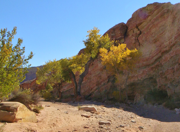
The hike started with an easy walk up a dry watercourse. The dampness remaining in the sand in the shady areas let me know that the isolated showers that had passed by the day before hadn’t skipped this canyon. The cottonwood trees were decked out in their bright fall yellows and my earlier “oops” was quickly forgotten.fallfall2

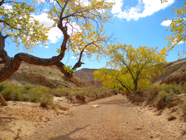
After a short while, Topper and I came to a couple of nice pools in some large rocks blocking passage in the otherwise-dry river bed.  Another couple that were hiking the canyon stopped to admire them.   While the woman was taking pictures of the pools,  the man tried by-passing the rocks on the right, which I could see wasn’t going to work. The rock shelf he was walking on ended about ten feet in front of him.

"impassible pools"

“impassable pools”

On the left side of the draw was another possible path, this one marked with a pile of rocks that indicated the trail. As I started hiking up it I heard the man say to his wife, “well, there’s no way to get around those rocks this way. I guess we’ll have to turn around.” Huh? I kept my mouth shut. He could see me going around the corner on my side. I got the impression that hiking the canyon was her idea and he didn’t really want to. Not my business.

Once around the barrier the challenge became choosing the easiest path back down to the sandy bottom. The first route I chose turned out to have a very steep, sheer rock incline as its final leg. I knew my new hiking boots had great traction, but I decided to look at another possible route. This one turned out to be much easier with far less possibility of having to end up in a (hopefully) controlled slide to the bottom.

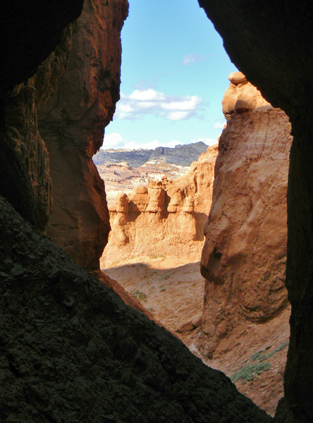
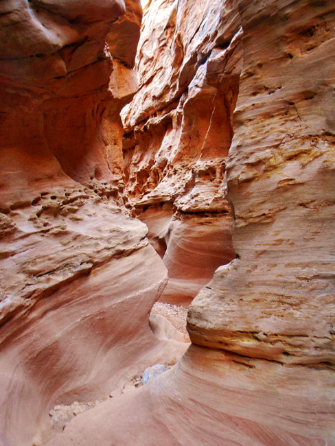
That behind me, the rest of the hike turned out to be very easy. No steep climbs, no treacherous, narrow ledges, just stroll in the sand, step over a couple of rocks, stroll, etc. Sweet. It wasn’t too long before the walls of the canyon began to close in. I was told that this was a slot canyon, and indeed it was.

over or under?

over or under?

The Narrowing

The Narrowing

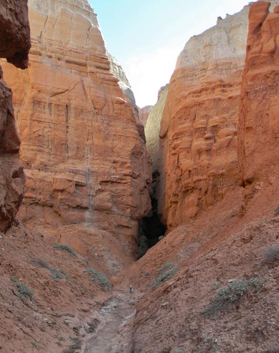
The banded, red walls became closer and closer together until I found myself edging sideways through certain areas. As I exited this first passage I thought I might have come to the end of this little adventure, but as I rounded the corner I saw that the canyon walls came together again. This time even narrower with far more twists and turns.

winding road

winding road

slot canyon

slot canyon

Topper, up to this point, was handling everything wonderfully. He was channeling his inner mountain goat to the max. Every now and again I wouldn’t be able to find him…until I looked up. He kept finding every little ledge, rock and shelf within reach of his little doggy legs and checking them all out for some new adventure. At least until we hit water.

The one thing Topper hates and fears is water. He has no idea that walking out in front of a swiftly moving car is dangerous. He will stand at the very edge of a high cliff and let his ears flap in the breeze. But three or four inches of water leaves him quivering, whining and shaking.

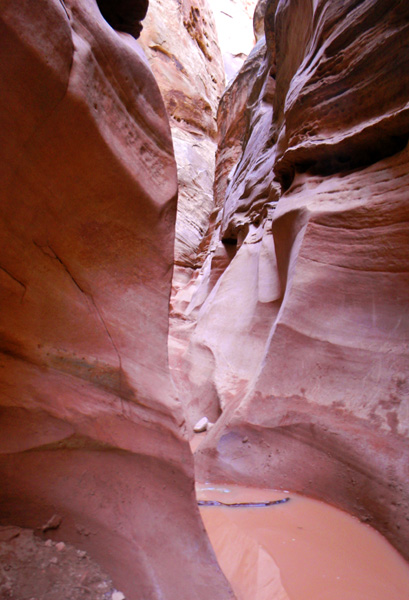
So when the canyon began its really skinny, tortuous turns with water, a good four to even six (gasp!) inches deep in some areas, that was it for the dog. I managed to drag him through the first section (which had rocks to walk on, large enough for my feet), but the second was too much. My new boots, which have mesh uppers for breathe-ability, were said to be waterproof. Amazingly enough, they really are! Let’s hear it for Merrill boots! Topper knocked me into the puddle twice while I was persuading him to continue.

Unfortunately, the next section was a couple of inches deeper, with no rocks, and a sharp turn in the middle. I would either have to wade or do a partial “chimney” action to stay out of any water that would top my boots. (I used my walking stick to measure the depth.) And there was no way I could do that carrying the dog. I was only three feet ahead of him at this point and he was crying and whining and simply beside himself that he couldn’t get to me past all that terrible water!

Topper's nemesis

Topper’s nemesis

I didn’t have the heart to leave him there and I didn’t have the hardheartedness to just clip on his lead and drag him through. All he had on was his slip collar, which would have choked him terribly. I hadn’t thought to put his harness on, not knowing about the water. If he had been wearing the harness, he could have learned that a little water and mud wouldn’t kill him and I could have seen the top of the canyon. Oh well. Live and learn.

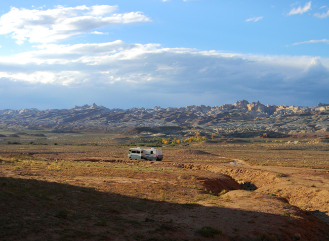
We turned back, I got to test out my waterproof boots one more time getting my big baby back through the first section (yep, still dry). Then we hiked back to the RV and headed back toward the main road. Once there, we stopped at a camping area just to the left of the junction. A grand total of about 20 miles from where we had just spent the past two nights. At least we had a start on the next stage of our journey. And I still had a little energy left for picking tiny pieces of glass out of the carpet.

heading for camp

heading for camp

Valley of the Goblins

I arrived on the outskirts of the Goblin’s valley yesterday. I set up camp on a small flattish area along a dirt road just below the base of a cliff on the opposite side of the road from a feature known as the San Rafael Reef. The reef rises hundreds of feet above the road leading to Little Wildhorse Canyon. A place I will visit in the next day or two. But this story is about the area just outside Goblin Valley.

campsite seen from cliffs

campsite seen from cliffs

my campsite, view one

my campsite, view one

The Valley itself is surrounded by high, steep cliffs in variegated colors of red, green, gray-white and ocher. The cliffs take a serpentine course undulating nearer and farther from the canyon road. There are many well-used dirt roads that traverse the alluvial deposits that line the base of the cliffs. Some are fairly smooth, all things considered (the roads are not maintained by anyone. They exist only because of their almost constant use.) These hard-packed clay tracks lead to flattish areas that have been used by tenters, campers and RV’s for decades.

I chose a road that already had a few people in residence, but which appeared to have a relatively flat area along a dry ravine that sees water only during the infrequent rains which pass through this area. What I saw from the road below turned out to be larger than it first appeared and with a gentle enough slope that the jacks on my RV had no problem setting everything level.

bottoms up!

bottoms up!

Once my home base was established, Topper (my dog) and I set out on a small, exploratory hike. We got a little carried away, maybe. What I had planned as a short jaunt turned into an almost two-hour exploration of the short, tortuous canyons that are inset into the cliff face at every turn. They all end within a few feet to, at most, a couple hundred feet or so at some shear drop from the mesa above. They were all carved by centuries of sporadic desert rains that cascade down the sides of the mesa to the valley below. And they are all beautiful and different.

weird desert plants

weird desert plants

banded cliffs

banded cliffs

window

narrow canyon

narrow canyon

While on our explorations, I found some interesting rock specimens (including one with some nice crystals inside) and saw a pale purple aster-like plant that had managed to survive being buried in sand during some rain event and had pushed its flower stalk above the soil to let its blossoms shine against an otherwise rather drab backdrop.

tenacious flower

tenacious flower

As night fell, we watched the moon rise above the cliff behind our little dwelling then went inside for a quiet supper. Later that evening, when I took Topper for his final stroll of the evening, I could see campfires in several places across the valley where it was spread out below us. The half-moon provided more than enough light to see the features of the canyon in dim relief. The moon was surrounded by a tight, glowing, pale-yellow halo, usually indicative of a coming rain. We shall see what the next 24 hours brings.

last flight

last flight

moonrise

moonrise

The next day we met the two families who were camped above us. Two retired woodworking teachers from the Provo area and their spouses. Topper found a playmate in one of their dogs and we were invited to share lunch with them. I’m glad I accepted. The food was delicious and the company pleasant. We took our leave shortly after the meal as one of the couples had to pack up and return home. The other couple is staying until tomorrow.

Topper and I took another exploratory stroll in the late afternoon, this time heading in the opposite direction from the day before. We rounded a turn in the cliff and were rewarded with a view of the back side of Molly’s Castle, a prominent feature of the area which marks the entrance to Goblin Valley.

Molly's castle

Molly’s castle

We reached an impasse and headed back toward some of the small side canyons which we had yet to explore. Topper got side-tracked by some small hole that to him apparently smelled wonderful. He spent several minutes making it much larger in pursuit of the denizen of said hole. He never caught up to whatever he was after (not that I thought he would, desert rats are smart enough to have several openings to their dens and many tunnels to use to escape would-be diners.) When I tired of watching his antics we headed off to explore the section that we hadn’t yet seen.

Reef detail

Reef detail

San Rafael Reef

San Rafael Reef

Topper's pursuit

Topper’s pursuit

A couple of the little canyons (or very tall gulleys, if you will…) were quite nice. One even had a small bridge that had formed when two large rocks collided when they slipped from their moorings on either side the lodged together in the middle. We passed underneath and continued about another 75 feet up the incline, until it became too steep for further exploration. Topper, who was pretty much a sissy-dog when we left St. Louis has become much more adventurous during our travels. I think he’s gotten in touch with his inner mountain goat.

pregnant rock

pregnant rock

bridge

bridge

I saw a few more of the tiny (about 1/4 inch across), colorful flowers that dot the ubiquitous plants that exist here. They’re rather pretty flowers, but difficult to photograph. Not only are they quite small, but when fully open their petals are translucent and about as thick as wet tissue paper. Once the plants have bloomed they dry into small sticker bushes that you don’t want to sit on, step on barefoot (or dog foot, as Topper found out), brush up against with any bare skin or otherwise come into contact with. The stickers come out easily enough, but they aren’t comfortable while lodged in one’s skin.flowers, redflowers, yellow

As we returned to our dwelling the moon was once more rising over the mesa looming above us. I took the opportunity to photograph the various formations and features in the waning light and found that the goblins do, indeed, come out at nightfall; their faces evident in the photos I took. Rain clouds were coming in from over the reef. I don’t know if they will drop any moisture on us tonight, but they made for a dramatic sky as the sun set. They also brought with them a stillness and silence that whispered of a peaceful night to come. At least so long as the goblins don’t become too restless…goblins

A Great Divide

As much fun as visiting family near Denver was, I eventually had to move on. I needed to cross the Rockies and continue my westward journey. This was not done without some measure of trepidation. I had no idea how my new RV would handle on the steep rises and downgrades of the passage above Denver.

Denver itself is “only” about 5500 above sea level. High enough that the altitude and shortage of oxygen takes some getting used to. But no big deal in comparison to how high the Rocky Mountains actually are. Topper and I would be crossing at over 11,000 feet, quite a jump from where I had been for the past few days.

I needn’t have been concerned.

It turned out that the worst part of the trip was all the construction and the traffic back-ups created by it. The first section of stop-and-go lasted about 45 minutes and ended before I got really sick of it. The scenery was so nice that the slow-down simply allowed me more time to take it all in.

Approaching the Rockies

Approaching the Rockies

About the time the traffic started to flow again, the really steep climb started. Yes, I had to go a little slower, but not nearly as slow as many of the loaded semis. I only fell below 40 mph one time when I was blocked in behind a truck carrying a load so large that it was barely doing 20.

And through it all, the temperature gauge on my RV never wavered. It stayed exactly where it had been on the flattest roads. I was really pleased. There were a lot of cars sitting on the side of the road with their hoods open whose owners would have loved to say the same. I hit the Eisenhower Tunnel and sailed on through. The Eisenhower was the first of the two tunnels built through the peaks to facilitate the traffic flow across the Continental Divide. It carries the west-bound traffic. The Johnson tunnel was built alongside a few years later and carries the east-bound traffic. Both tunnels are quite long, but well-lit and are quite comfortable to drive.

Eisenhower Tunnel

Eisenhower Tunnel

Almost as soon as I exited on the other side of the divide, the really beautiful scenery started. Since it had snowed just a couple of days before, there was still plenty of snow on the higher peaks. Just enough to give everything that “picture postcard” look. Which meant that I felt obligated to stop at almost every scenic overlook to take a few pictures.

after exiting the tunnel

after exiting the tunnel

It had been at least 18 years since I had driven across this section of the Rockies, so all the pictures I have of the area predate the digital age. And many have suffered the fading colors that so many photos of the film-era have fallen victim to. So it was nice to have the chance to update my mementos of the area.

More fall color

A little fall color
A little fall color
Scenic overlook

Scenic overlook

There are several areas with long, steep down-grades on the other side of the divide–along with a few more steep climbs. The down-grades are posted with signs that limit vehicles over 26,000 pounds to speeds of 45 mph and under. They also let you know just how many miles that grade will last. The longest, steepest grades have special ramps built off the side of the road to allow trucks that lose their brakes on the way down to have a place to come to a stop. If you’ve never driven a really steep mountain road you don’t realize just how necessary they can be.

Truck escape ramp

Truck escape ramp

I was very happy with the way the new RV handled. It took the “downs” as well as it had taken the “ups”. It has a grade brake that allows the engine to take a lot of the load off the regular brakes–very similar to the type of braking system that a semi uses. Not as hefty, but it certainly got the job done. A flip of the switch and I never had to worry about my brakes over-heating. Since the manual that came with the RV lists its weight at around 22,000 pounds (without gas, water or personal items on board), it’s not something you want to have get away from you….

After the worst of the ups-and-downs was over, I stopped to take pictures at a rest area just before the off-ramp for Cooper Mountain. There was a stream and small lake beside the rest area with hiking trails leading off into the mountains. Topper and I took a short hike around the lake and gave our butts a rest and our legs a little work-out. We both enjoyed it immensely, Topper probably more than me. I can tell he misses the freedom to run without a leash that he enjoyed while we were in the Black Hills.

Reflections on our hike

Reflections on our hike

Cooper Mtn. exit

Cooper Mtn. exit

We later ran into another construction zone that took over an hour for us to clear, which meant that I didn’t get as far as I would have liked for the day. But so what…..if anything the section we were semi-parked in was even prettier than the last place where traffic was slow. We ended up stopping at a campground in the town of Silt and calling it a day. It was a nice enough place, located right on the edge of the Colorado River, and we had a peaceful and restful night.

Colorado River at our campground in Silt, C)

Colorado River at our campground in Silt, C)